The Ionian Islands

Introduction
Note: The following text is not a pilot book and should not be used as such but an introduction to cruising in the Ionian Sea born from more than 40 years of sailing in the area.
The Ionian Islands form an Archipelago of 21 inhabited and many uninhabited islands lying parallel and off the West coast of Greece in a long line of about 180 nautical miles. The size and the population of the islands varies from Corfu with 100.000 inhabitants to Strofades 26 miles South of Zante with a monastery and a population of just one monk.
Their main difference from the typical Greek islands of the Aegean is first that receiving much more rainfall they are very green, second that they are not subject to the Meltemi the NorthEaster wind which in the summer months in the Aegean reaches force 5 and 6 and some times more for days on end making holidays with a boat and family rather tough.
The great number of the islands means that distances between them are small the biggest being from Paxos to Lefkas -32 miles from port to port-.
The Ionian Islands being for many centuries on the frontier between the Eastern and Western world have had a turbulent history and innumerable occupiers.
Starting with ancient Corinth of which Corfu was a colony before becoming independent, Romans, Byzantine, the dynasty of Anjou, the Venetians for four hundred eleven years for Corfu and less time for the other islands, and in the case of Lefkas the Ottomans for a short period.
In more recent times the democratic French after the French revolution, the Russians and Ottomans for a short period, then the imperial French, finally becoming a semi-independent state under English protectorate until 1864 when they were united with Greece.
This history led to a varied cultural and architectural environment which makes them. In addition to the beautiful beaches and small coves, so interesting to the visitor.
The islands have a long history connected to the sea, from being the home of Ulysses- Odysseus- of Homeric times, the Phaeacians of Corfu with a big navy to being the place of the Venetian naval high command for all their possessions in Eastern Mediterranean in the late Middle ages and up to the 18th century.
In more recent times they provided a lot of sailors for the merchant marine and a number of shipowners.
The prevailing wind in the Summer being from the Northwest creates sheltered areas to the East of the islands, and the same happens in winter with winds from the South-Southwest.

In the Summer months the Northwestern wind -MAISTRO- in Greek starts at about midday with force 3 and increases to a force 4 with occasionally a maximum of force 5, in the late afternoon. In the mornings if there is any wind it is variable from force 2 to 3.
So, if you travel from North to South you can sail from midday with following winds but if you travel from South to North and you do not want to beat to windward you motor. early in the morning.
In any case it is advisable before any trip to have a weather report.
The East coast of the islands sheltered from the weather, and in older times from pirate incursions, are where you find almost all small towns and villages and small and big harbors. The villages that you can see from the sea when travelling along the west coast are more recent built after piracy was eradicated in the Mediterranean.
The West coasts are wilder with very few shelters in the afternoon when the Maistro blows but with beautiful and in many cases deserted beaches.
Corfu – Kerkyra and adjacent islands

Corfu being the most populous is the administrative capital of the region of Ionian islands.
North of Corfu there are the three Diapontia islands, Othonoi, Errikoussa and Mathraki, with Summer populations of around 200 each. Errikoussa has a small marina, Othonoi a port safe in the Summer if it does not blow from the East- Southeast and Mathraki a small port for up to 3-4 yachts.
Corfu offers a lot of sheltered anchorages and small ports on the East coast starting from Kassiopi in the Northeast corner of the island opposite Albania going South to Lefkimmi just 4 miles North of its Southern tip.
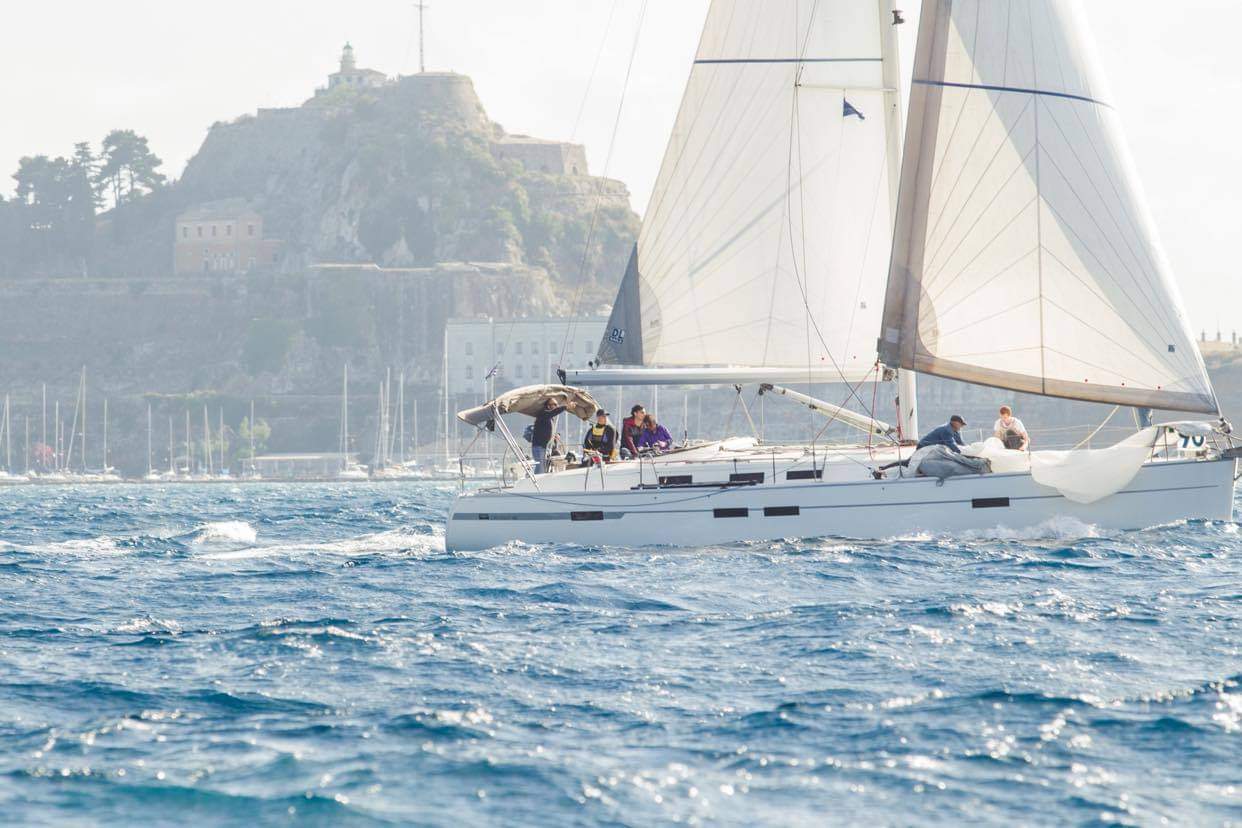
The old town of Corfu with a mixture of Venetian and English architecture with some French influence thrown in, is worth more than one day’s visit.
The town with a population of about 40.000 is the capital of the island offering everything a big town offers -banks, hospitals, shops, hotels etc.
And a number of museums, including one of the biggest in Europe of Chinese and Japanese art. The two Byzantine- Venetian – English fortresses make it an impressive place.
With a big -over 1000 places- marina at Gouvia bay and some small ones one can find everything one needs both for crew and boat and effect any needed repairs.
Corfu international airport is from May to October connected to most European big cities.
Cruising in Corfu.
The three islands in the North are worth visiting, unspoiled sandy beaches with relatively few tourists, nice walks among the olive groves, friendly small restaurants, and friendly inhabitants create an unforgettable experience.
The area between cape Ag. Aikaterini in the North to Corfu town with a lot of small coves and bays especially in the narrowest part opposite Albania, Starting from the North you find Kassiopi port a convenient place to spend an evening. Going Southwards San Stefano bay, Kouloura bay and a number of beaches where you can anchor.
Also, the North part of the West coast is very impressive with sheer cliffs interspersed with sandy or pebbly bays nice for a swim, if the weather is good. The port of Palaiokastritsa, the only port on the west coast offers good shelter and the possibility of anchoring in the bay if you don’t find space to moor with plenty of restaurants and bars.
Corfu town offers apart from Gouvia Marina which is about 3 miles distant, three small marinas practically in the town. One in the old harbor on the North side, one a little further away under the fortress, seat of Corfu Sailing club and one South of the fortress seat of Corfu Nautical-Athletic club.
Benitses marina 4.5 miles South of town in front of a very touristically developed fishing village. The coast from the town to cape Lefkimmi is protected from the prevailing winds and offers a lot of anchorages, some of them in front of beach restaurants.
South of Corfu at a distance of less than 8 miles lie Paxos and Antipaxos islands a must for visiting by any cruising yacht. Paxos has three harbors Lakka in the North a sheltered enclosed bay where you can anchor – or if arriving early find one of the few places in the quay. Lacca offers a lot of restaurants and basic grocery, fruit and vegetable supplies.
Gaios the capital of the island has a fiord like very safe harbor with plenty of mooring spaces but it fills up early during July and August so if you want to find a place you have to arrive in early afternoon. It offers all kind of supplies In between the two is the Longos picturesque small port but not very safe at night.
Antipaxos island has two beautifull beaches with emerald waters on the Northeast corner and a number of rocky coves and small beaches both on the East and West coasts.

Useful addresses and telephones
PORT AUTHORITIES PHONE NUMBERS
| Corfu | +30 26613 65200 |
| Sivota Mourtos | +30 26650 93100 |
| Paxos | +30 26620 32259 |
| Lefkas | +30 2645 022322 |
| Fiscardo | +30 26740 41400 |
| Ithaka | +30 26740 32909 |
| Patra | +30 26136 15400 |
| Zakinthos | +30 26950 28118 |
VHF RADIO CHANNELS
| Port Authorities | 12 |
| Lefkada Bridge | 12 |
| Bridge Rio Adirio | 13 + 14 |
| Corinthos Canal | 11 |
| Mandraki | 68 |
| Marina Gouvia | 69 |
The mainland coast opposite Corfu
In the North is the coast of Albania.
In Greece the port of Igoumenitsa on the end of a very deep bay is busy with ferry traffic from Italy and Corfu but with few amenities for yachts.
South of Igoumenitsa is Plataria bay with a safe yacht harbor on the waterfront of the village of the same name, and further South the port of Sivota with a yacht harbor and nice bays for swimming.
From Sivota to Parga there are a lot of small coves and bays for anchoring and swimming if the Maistro is not blowing.
North of Parga is a nice anchorag on the West side of Valtos bay or moor bows to, inside the breakwater, or you can anchor in front of the town of Parga in settled weather. East of Parga are the nice bays of Ag Kyriaki and Ag. Ioannis more sheltered from the Maistro.
Between Parga and Preveza there are a lot of beaches but all open to the Northwestern afternoon wind with the exception of Fanari bay and the next one about 2 miles South of it.
There are only two small harbors, Lygia about 11 miles Southeast of Parga with a difficult entrance due to rocks just outside, (you should not try to enter at night) and further South at 22 miles from Parga Mytikas but with useful depths behind the breakwater only just halfway from the North side of it.
Preveza which is a sizeable town with all you could need is approached through a Boyed channel long about 2 miles. You can anchor stern to in front of the city promenade or in the marina just to the North of the end of the promenade.
Opposite Preveza in Aktio there is Cleopatra marina and 3 boatyards with facilities to take a boat out and leave it for the winter.
Amvrakikos bay East of Preveza has on its Southern shore the little town of Vonitsa with a port and a medieval fortress.

Lefkas – Lefkada
The town of Lefkas the island’s capital is situated in the Northeast end of the island and is approached via a narrow channel interrupted by a floating bridge connecting the island with the mainland.
The bridge opens every hour on the hour. If you arrive early you can wait before the bridge in the protected waters behind the breakwater, either anchored or idling with the motor. When the bridge opens outgoing traffic goes first.
0.6 miles after the bridge along the channel you arrive at Lefkas port where you can moor stern to. Southeast of the port about 0.3 miles along the channel is the entrance of Lefkas marina.
Lefkas town with a population of …… has banks , a hospital, ship chandler shops and general shops.
It is a nice place to replenish stores and fuel before continuing South.
Leading South of Lefkas is a channel about 2 miles long buoyed on both sides with a depth of 5.5 meters through which you reach the Inland sea and islands between Lefkas and the mainland, a cruisers paradise.
The inland sea of Lefkas
The area bound in the West by Lefkas and Ithaka and in The East by mainland Greece is protected in the Summer by the prevailing winds. The area from Lefkas to the South of Ithaca with a length of about 30 miles and a width of about 17 miles offers over 20 small islands of which only five are inhabited, three marinas, 25 small harbors and innumerable bays and beaches.
Out of the Southern entrance of Lefkas channel you meet a series of small ports, the first just 0.4 miles away being Lygia which is mainly a fishing port but with some places for yachts but not very quiet at dawn when the big fishin g boats arrive and unload their catch.
Two miles from the entrance is Nikiana much better to stay for the night.
If you continue South and you pass to the West of Sparti island opposite the island is Perigiali an open quay but safe with the prevailing Northwest summer wind where you can find fuel.
Further South is the busy port of Nydri with a lot of cafes and restaurants just across from the quay and exactly opposite is a very enclosed bay called by yachtsmen tranquil bay where you can anchor and cross to Nydri with the dinghy for shopping and entertainment.
South of Nydri through a narrow channel with minimum depths of 8 meters you reach the lake like Vlicho bay.
The island of Meganissi offers two ports and a small marina and two very deep fiord like bays on the North side.
East of Meganissi are the small islands of Kalamos with a small harbor on the North side and the main harbor on the South, and Kastos with one on the East side of the island.
On the mainland coast in the North opposite Nydri and a little to the North of it is Palairos bay with a port and a small marina 0.5 miles further South of it.
North of the Northeast end of Kalamos is the small town of Mytikas with a small port. And further South in the end of a deep bay behind a lot of small uninhabited islands the town and port of Astakos.
On the South side of Lefkas there are a small Marina on the westernmost bay -Vassiliki, and more to the East in a very deep and enclosed bay the harbor of Syvota.
The island of Ithaka -Ithaki to the Greeks offers 3 ports on the East side.
In the North Frikes bay but with bad anchor holding and suffering from the Northwestern wind from very strong downdrafts from the mountain behind.
A little further south Kioni, a very picturesque village with a safe harbor and still further South Vathi the capital of the island in a very deep bay.
Kefalonia
Kefalonia is the least touristically developed of the Ionian islands, it has though excellent wines, its white Robola its unique and very good quality cheese from local sheep and goat herds. Because the island was leveled by a huge earthquake in 1953 You don’t see many old buildings.
The best-known port for yachts of Kefalonia and one of the most picturesque is Fiscardo at the East side of the Northern tip of Kefalonia if its full you can anchor at the deep bay less than 0.5 miles to the South and go to Fiscardo by dinghy.
The East coast of Kefalonia from Fiscardo to the Marina and village of Ag Eufemia, with a length of about 8 miles, is a series of small bays and beaches mostly inaccessible by roads and so very nice for anchoring and swimming in the deeper bays also for overnight stays.

3.0 miles South of Ag. Euphemia is the port and yacht harbor of Sami, not a picturesque little town but with shops restaurants and a small medical facility.
Further South at a distance of about 12 miles is the port and town of Poros with a lot of tourism.
The west coast of Kefalonia has the small port of Assos overlooked by a Venetian fortress but with limited quay length. The quite bay of Atheras has a stone breakwater in its Southern end behind which you could stay in a moderate Northwestern wind.
On the South coast of the island are the two bigger towns of the island Argostoli the capital with a population of bout 6.000 and opposite to the West Lixouri with a much smaller population. Both have ports and Argostoli a small yacht harbor and an unfinished marina opposite the town quay.
The bay of Argostoli is subject in the afternoon of the Maistro which due to the surrounding mountains is stronger than in the open sea. Further South of Argostoli and to the East is the small marina of Ag. Pelagia.
Zante
Just 15 miles Southeast of Ag. Pelagia or about 16 miles from Poros is the very attractive port of Ag. Nikolaos South of the Northern tip of Zante -Zakynthos to the Greeks.
About 13 miles Southeast of Ag. Nikolaos the town of Zante capital of the island has a very big harbor and just on its South side a marina.
The town is attractive and has shops of all kinds and a hospital. Zante has an international airport connected in the summer to many European cities.